High Points
I learned about High Points about three years ago when I was passing through Lone Pine, CA, the closest town to Mt Whitney, which is the highest point in the lower 48 states. No, I have not attempted Mt Whitney, yet. We also learned of highpointers, a group of people that set out to reach the high point of all 50 states. We thought that would add an interesting touch to our travels. I have no intention of reaching all 50 highpoints. Five of the highpoints require technical mountaneering skills and specialized equipment. Dianne has rebelled at just the idea. As of the end of this trip we have conquered ten state High Points.
I just learned that in addition to the High Points, some folks have also gone to the state Low Points.
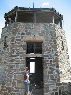
Here is Harney Peak at 7242 feet, the High Point of South Dakota. Shown is an abandoned fire tower that was constructed by crews during the WPA days. It is listed in the national historic register.
View from the top of Harney Peak.

Timms Hill, at 1951 feet, the High Point of Wisconsin. It is about 1/4 mile from the parking lot of a county park.

I brought along my support group for this arduous climb. Here we are at the top of a wooden lookout tower which is next to a steel fire tower (closed to the public).

Charles Mound at 1235 feet, the High Point of Illinois. Charles Mound is located on private property. It is about a 1.5 mile hike from the road. The landowner only grants access to this property four weekends a year, during the summer months. From here Iowa, Wisconsin and, of course, Illinois can be seen.

I tried to put this all into one post, but Blogger would not allow more than five photos in a single post. Consequently, the rest is below.
I just learned that in addition to the High Points, some folks have also gone to the state Low Points.
Here is Harney Peak at 7242 feet, the High Point of South Dakota. Shown is an abandoned fire tower that was constructed by crews during the WPA days. It is listed in the national historic register.

View from the top of Harney Peak.

Timms Hill, at 1951 feet, the High Point of Wisconsin. It is about 1/4 mile from the parking lot of a county park.

I brought along my support group for this arduous climb. Here we are at the top of a wooden lookout tower which is next to a steel fire tower (closed to the public).

Charles Mound at 1235 feet, the High Point of Illinois. Charles Mound is located on private property. It is about a 1.5 mile hike from the road. The landowner only grants access to this property four weekends a year, during the summer months. From here Iowa, Wisconsin and, of course, Illinois can be seen.

I tried to put this all into one post, but Blogger would not allow more than five photos in a single post. Consequently, the rest is below.


Comments